
Hurricane Debby reached the Big Bend coast of Florida early Monday, bringing with it the potential for catastrophic flooding and life-threatening storm surge as it slowly passes over the northern part of the state. Forecasters warned that, in the coming days, record-setting rain could pummel coastal Georgia and South Carolina as the storm heads east.
The National Weather Service forecast model as of Monday morning shows the center of Debby passing south of the Bulloch County area Tuesday. Bulloch County has been placed under a tropical storm watch, which means winds of perhaps 35 mph are possible in the area. The storm could bring more than 10 inches of rain, higher in some local areas, between Monday and Wednesday, according to the NWS.
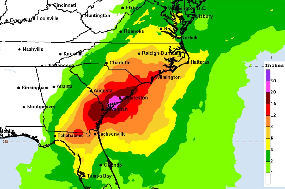
“Across portions of southeast Georgia and South Carolina, 10 to 20 inches of rainfall, with local amounts to 30 inches, are expected through Friday morning,” the NWS said in its forecast. “This potentially historic rainfall will likely result in areas of severe and widespread flash and urban flooding, with significant river flooding expected.”
While the current forecast doesn’t include tropical storm-force winds in Bulloch, gusts could reach 25-30 mph.
The storm made landfall as a Category 1 storm near Steinhatchee, a tiny community in northern Florida of less than 1,000 residents on Florida’s Gulf Coast. It had maximum sustained winds of 75 mph and was moving north-northeast at 10 mph, the National Hurricane Center in Miami said.
After making landfall, the storm is expected to move eastward over northern Florida and then stall over the coastal regions of Georgia and South Carolina, thrashing the region with the potential of record-setting rains totaling up to 30 inches beginning Monday.
Flooding impacts could last through Friday and are expected to be especially severe in low-lying areas near the coast, including Savannah, Hilton Head and Charleston.
Officials in Savannah said the area could see a month’s worth of rain in four days if the system stalls over the region.
“This is going to a significant storm. The word historic cannot be underscored here,” Savannah Mayor Van. R. Johnson said during a press conference.
“Storm surge inundation of 2 to 4 feet is possible along the Southeast Georgia and Southeast South Carolina coast, especially Tuesday through Thursday,” the NWS advisory stated. “In addition, isolated tornadoes will be possible, with highest chances across coastal areas.”
Debby is the fourth named storm of the 2024 Atlantic hurricane season after Tropical Storm Alberto, Hurricane Beryl and Tropical Storm Chris, all of which formed in June.
In preparation for the storm, Georgia’s State Operations Center (SOC) is now operating at full-scale activation level. Georgia Emergency Management and Homeland Security Agency (GEMA/HS) will continue to monitor the storm and is ready to assist local emergency management agencies should the need arise.
“As our agency braces for potential impacts from Tropical Storm Debby, we’d like to encourage all residents and visitors to pay attention to trusted news sources, weather alerts and local officials,” said GEMA/HS Director Chris Stallings.
For more information on how to prepare, visit https://gema.georgia.gov/plan-prepare/ready-georgia